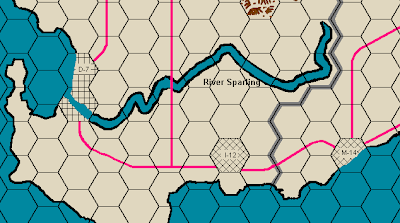
This here graphic is a small piece of the gameboard for the classic Avalon Hill wargame Blitzkrieg. The crisscrossed hexes are urban areas, the graphic effect used meant to suggest intersecting city streets. I happen to own a copy of the Blitzkrieg board but not the game itself. A couple of days ago I was looking at this map and it occurred to me that I should be looking at the white squares on those hexes instead of the black lines. As a series of crowded white squares those hexes look kinda like a patchwork of cultivated farmland. In other words, imagine those hexes are where farms are clustered around villages or castles. Bam! Instant D&D campaign map.
I've never been completely satisfied with the results of my original World of Cinder sandbox map. I can't draw for anything and as much as I like the paper I used (an original Judges Guild blank wilderness hexmap), the hexes are just a smidgeon too small to comfortably fit counters. So maybe this old board could be drafted into use as another part of my campaign setting.


.JPG)


.png)


.gif)


Go Red! or Blue!?
ReplyDeleteWell whatever color have fun with it.
D7 and I12 make sense, but M14 should be M12, right?
ReplyDelete...
B7! You shanked my jengaship!
I shanked your jengaship? We're playing Connect 4!
ReplyDeleteThe alphabet runs east to west but the numbers are aligned along the diagonals.
That's an inspired idea, fully in line with the use of the Outdoor Survival game board mentioned in the original.
ReplyDeleteI could also see some of those old World War III operational SPI games pressed into service (Fulda Gap, etc.), or maybe the maps for Steve Jackson's GEV.
I've had this same idea for a long time now -- I just haven't actually done anything with it.
ReplyDeleteAnd thus did Sturmgeshutz and Sorcery (or: How Effective is a Panzerfaust Against a Troll?) return from the distant past to enrich our lives...
ReplyDeleteI have a page that generates campaign maps, for those that don't have wargame maps. It has the problem that it doesn't emphasise the boundary between land and sea as it should, but they're useable: www.apolitical.info/webgame/map
ReplyDeleteMan I had more than a few wargames with giant maps that take up several tables. Now I mostly have North Afrika games and that's not all that varied of terrain.
ReplyDeleteYou know Squad Leader/Advanced Squad Leader. That game has like 40-70 geomorph hex boards. Woods, towns, cities, hills, also desert and jungles. Could totally use those for smaller scale maps. I think they are 30m hexes, but fudgeable to what you need within reason.
I've decided to follow the time honored tradition and rip off real maps, Google most recently.
Just remember that River Zocchi is a difficult one to cross.
ReplyDelete